NASA-ISRO Synthetic Aperture Radar Mission
Blog Credit: Trupti Thakur
Image Courtesy: Google
ABOUT NISAR
The NASA-ISRO Synthetic Aperture Radar mission is a joint project between NASA and ISRO to co-develop and launch a dual-frequency synthetic aperture radar on an Earth observation satellite. The satellite will be the first radar imaging satellite to use dual frequencies.
The NASA-ISRO SAR (NISAR) Mission will measure Earth’s changing ecosystems, dynamic surfaces, and ice masses providing information about biomass, natural hazards, sea level rise, and groundwater, and will support a host of other applications.
NISAR is expected to be launched in January 2024 from Satish Dhawan Space Centre into a near-polar orbit.
NISAR has a ~ 240 km swath, 7 m resolution along track and 2-8 m resolution cross-track (depending on mode). In this way, SAR beats the resolution limits of what can physically be put in space to provide images and science of much higher quality than would be possible if the antenna size was used as is.
NISAR is estimated to be the world’s most expensive Earth imaging satellite. The total cost of the project includes ISRO’s work share cost of about Rs 788 crore and about $808 million of JPL’s.
The satellite will be the first radar imaging satellite to use dual frequencies. It will be used for remote sensing, to observe and understand natural processes on Earth.
According to a cooperative agreement inked in 2014, the US and Indian space agencies collaborated to build NISAR. It is anticipated to be launched from Satish Dhawan Space Center into a close-polar orbit in January 2024. At least three years will pass before the satellite stops working. It is an observatory in low Earth orbit (LEO). The entire world will be mapped by NISAR in 12 days.
FEATURES OF NISAR MISSION
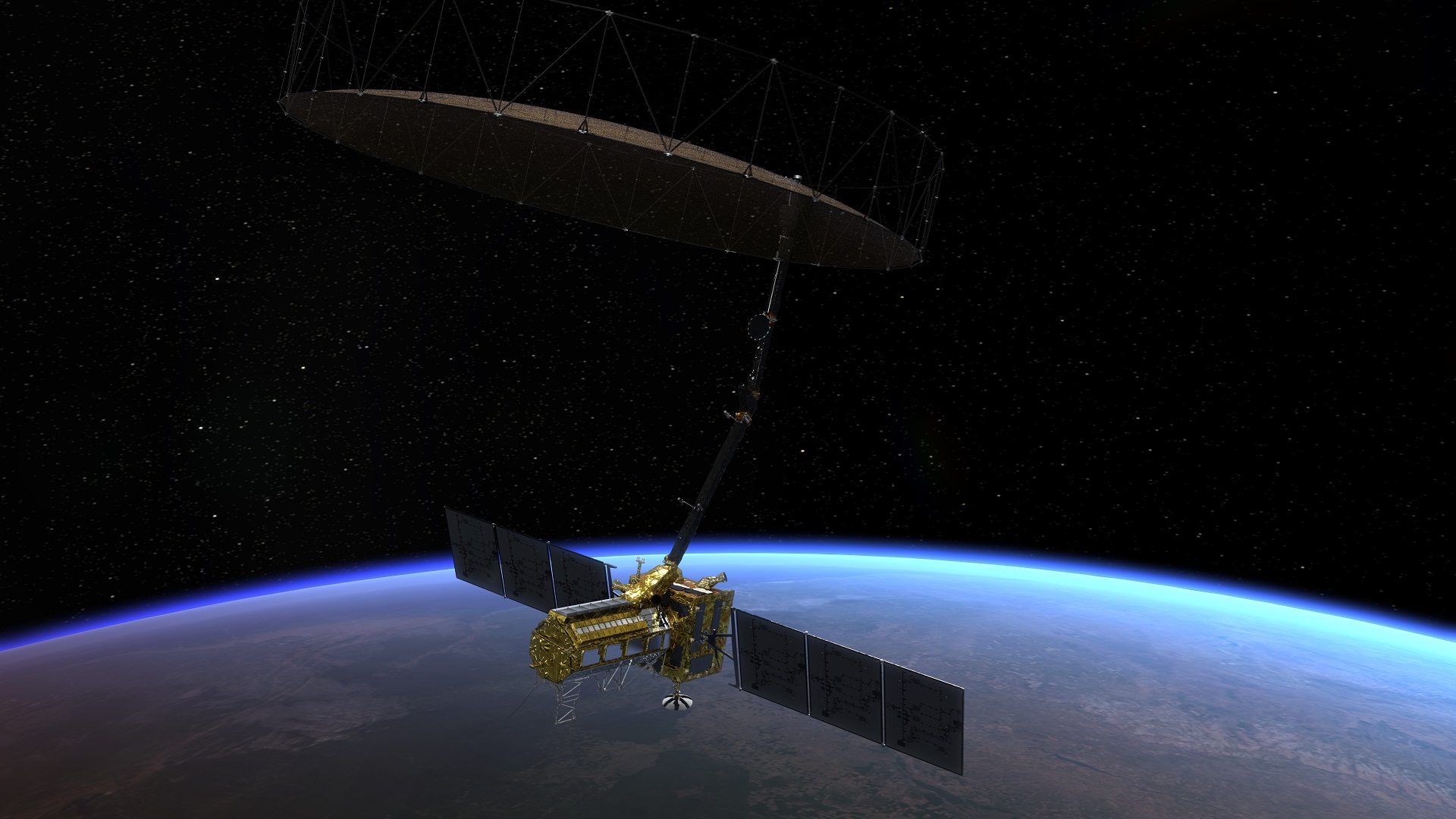
It is a dual-frequency imaging radar satellite weighing 2,800 kilograms and equipped with both L-band and S-band Synthetic Aperture Radar (SAR) instruments.
While ISRO (Indian Space Research Organisation) contributed the S-band radar, the Geosynchronous Satellite Launch Vehicle (GSLV) launch system, and the spacecraft, NASA provided the L-band radar, GPS, a high-capacity solid-state recorder to store data, and a payload data subsystem.
S-band radars function between 2-4 GHz and have a wavelength of 8 to 15 cm. They are difficult to attenuate because of their wavelength and frequency. They can be used for both local and global weather observation because of this.
Benefits of NISAR:
NISAR will provide information used to monitor ocean wind, waves, and sea-ice extent that can aid weather forecasting and warn of marine hazards. Its coverage of coastal oceans benefits sea transportation and coastal communities.
ISRO will use NISAR for a variety of purposes including agricultural mapping, and monitoring of glaciers in the Himalayas, landslide-prone areas and changes in the coastline. By using synthetic aperture radar (SAR), NISAR will produce high-resolution images.
In-depth details on the 5,465 satellites currently orbiting Earth, including their country of origin, purpose, and other operational details.
- Climate & environmental monitoring. Satellites are some of the best sources of data for climate change research.
- Land stewardship.
- Space science.
NISAR Mission
In order to focus the radar signals sent and received by the upward-facing feed on the sensor structure, it features a 39-foot stationary antenna reflector built of a gold-plated wire mesh.
NISAR will create high-resolution photos utilizing SAR. No matter the weather, SAR can gather data day or night because it can penetrate clouds.
For at least three years, NASA will need the L-band radar for its global science operations. The S-band radar would be used by ISRO for a minimum of five years.
The NASA Jet Propulsion Laboratory (JPL) in California, United States, recently held a send-off ceremony for NISAR (NASA-ISRO Synthetic Aperture Radar).
Using two distinct radar frequencies (L-band and S-band), NISAR will be the first radar of its kind in orbit to methodically scan Earth. It will measure changes in our planet’s surface that are less than a centimeter across.
L-Band
The Institute of Electrical and Electronics Engineers (IEEE) refers to the radio frequency band between 1 and 2 gigahertz as the L band (GHz). This is at the top end of the ultra-high frequency (UHF) band and the lower end of the microwave spectrum.
S-BAND
The Institute of Electrical and Electronics Engineers (IEEE) refers to the microwave band, which covers frequencies between 2 and 4 gigahertz, as the “S-band” (GHz).
As a result, it crosses the normal boundary between the UHF and SHF bands at 3.0 GHz. Several communications satellites, including those used by NASA to interface with the Space Shuttle and the International Space Station, weather radar, surface ship radar, airport surveillance radar for air traffic control, and some satellites used for communications.
ADVANTAGES
Earth Science
NISAR will offer a wealth of information and data about changes to the Earth’s surface, natural disasters, and ecological disturbances, advancing our knowledge of Earth’s system processes.
Disaster management
The mission will deliver crucial data to aid in the management of natural disasters like earthquakes, tsunamis, and volcanic eruptions, enabling quicker response times and better risk assessments.
Farm
NISAR data will be utilized to provide information regarding crop growth, soil moisture, and land-use changes in order to improve agricultural management and food security.
Infrastructure Monitoring
The mission will offer information for managing and monitoring infrastructure, such as keeping an eye on deforestation, urbanization, and oil spills.
Climate Change
NISAR will assist in seeing and comprehending the effects of climate change on the terrestrial surface of the planet, such as melting glaciers, rising sea levels, and modifications in carbon storage.
Way ahead
- The Satish Dhawan Space Center is scheduled to launch the three-year NISAR mission in 2024. NISAR will be used by ISRO for many different tasks, such as mapping agricultural areas, monitoring glaciers in the Himalayas, and landslide-prone regions, and observing changes in the shoreline.
- The S-band radar will be used by ISRO for at least five years. For at least three years, NASA will need the L-band radar for its global science operations. Losses caused by calamities must be reduced for our society and economy. To implement effective mitigation and make the most of our resources responsibly and economically, we need to make educated decisions.
- We can decipher other impacts and comprehend processes taking place at depth by measuring movements and other changes on the Earth’s surface. With the aid of NISAR data and scientifically based management and storage of freshwater and energy sources, resources can be used more effectively and sustainably.
- The informationfrom NISAR can assist people in different parts of the world manage natural resources and risks effectively. It can also help scientists better understand the consequences and rate of climate change.
Blog By: Trupti Thakur
17
FebNISAR- NASA-ISRO Synthetic Aperture Radar Mission
Feb 17, 2023Recent Blog

The ITES-QApr 17, 2025

The UPI Circle Of PhonePeApr 16, 2025

Dangerous AI In HealthcareApr 15, 2025

Google’s Iron Wood ChipApr 14, 2025

World’s First 3D Printed Train StationApr 11, 2025